Saturday, March 15th, 2014 at 8:11 am by ba3 — Category: Demo
Today BA3 is pleased to announce the Alpha release of BA3′s Altus Mapping Engine running in the browser. This is the same great Altus engine, cross-compiled for the Web and running in the Chrome and Firefox browsers on Windows 7/8 and OSX.
This demo is so rich and interesting that we are providing this guided tour to help you see everything there is to see in Today’s release:
- Start by going to the alpha release page and clicking the “Live Demo” button. Now try the following…
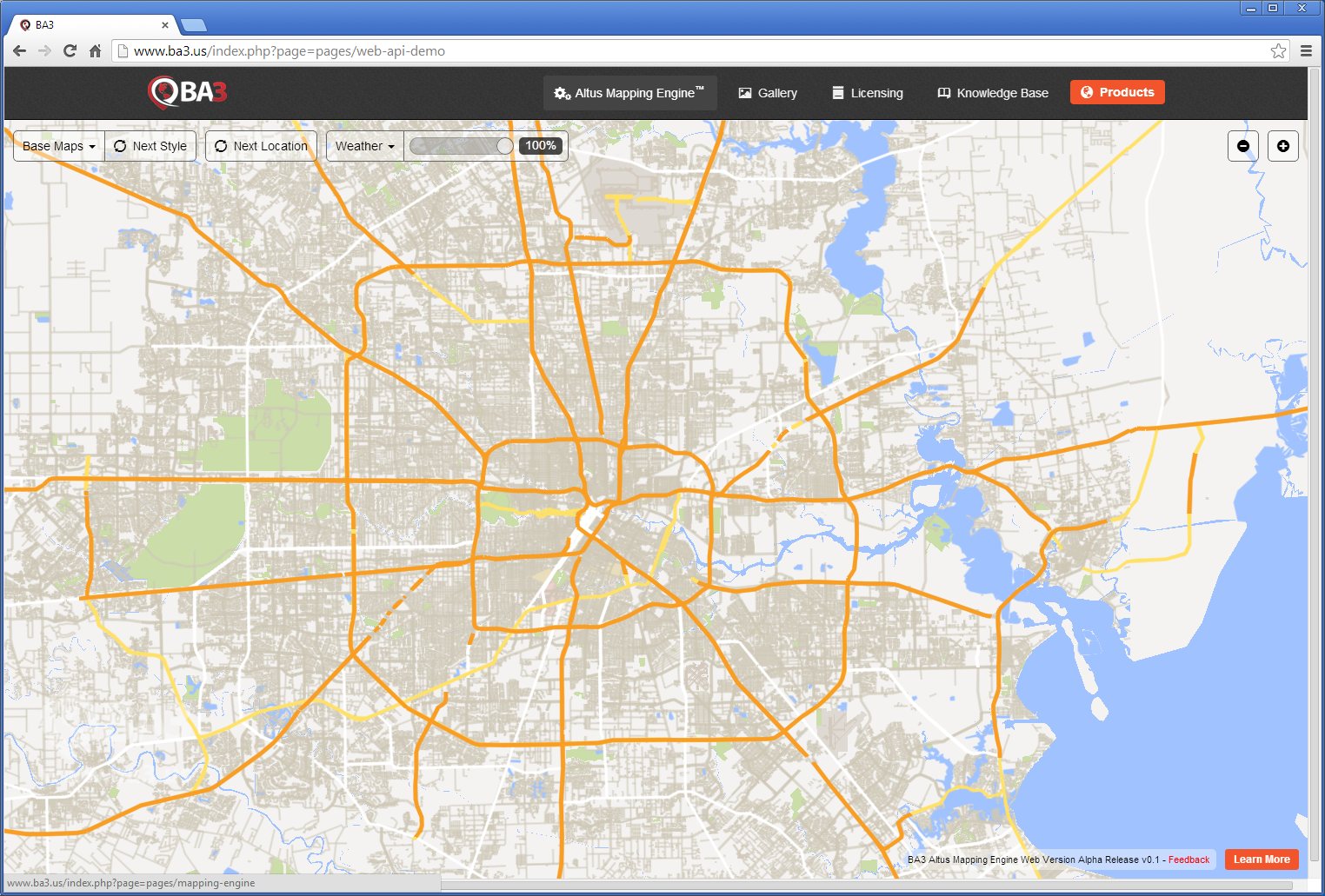
- When the demo opens, you are looking at a base map called “Houston Streets” that is a vector map of the world. This is probably the first time you have seen a pure vector map displayed in a browser at this performance level. This vector map contains:
- Political boundaries for the world
- State boundaries and some water and forest features for the United States
- Major Highways for much of the state of Texas
- Surface streets in full detail for the city of Houston
- Feel free to pan and zoom with your mouse to see different parts of the world.
- Click the “Next Location” button. You will see animations to different areas of the map and different zoom levels that we feel are particularly illustrative.

- All of the data in the “Houston Streets” base map is derived from the OpenStreetMap database using BA3′s vector tool called MapShop. Developers and cartographers can use MapShop to select and style vector data to create their own custom vector maps like this one.
- The “Next Style” button demonstrates one of the big advantages and distinguishing features of vector maps: they can be restyled on the fly. Click “Next Style” to cycle through three different styles. The styling is controlled by tiny style files that are easy for you to create in MapShop.
- Note that this entire vector map requires a file only a few megabytes in size. This is another advantage of vectors.
- If you select the “Cultural” base map, you will see one of the smallest vector maps possible. This vector file contains political boundaries for the world and is only 1.4 MB in size compressed. Zoom in tightly. Imagine how big the tile set would be at that zoom level. Vector files can be extremely compact compared to tiles.
- You can select 4 other base maps. These are publicly available tile sets from Mapbox, OpenStreetMap and MapQuest. Altus can handle any public tile set. [Note that, if you have your own custom tile sets, they are easy to display in the BA3 Mapping Engine. They will be automatically re-projected onto the sphere - you do not have to do anything to make your flat tile sets appear beautifully on the sphere. WMS sources are also supported in Altus.]
- Choose a base map that you like. Click the “Next Location” button. You will see animations to different areas and zoom levels that we feel are particularly illustrative.
- Zoom out over the United States. In the Weather menu, try turning on the Current Temperature layer. The adjacent slider changes the transparency (alpha) of the overlay. Play with it. Try changing the base map under the overlay. Also try the Probability of Precipitation overlay.
Thank you for trying out the demo today. If you have comments and suggestions, please add them here: Alpha release feedback. Or feel free to contact BA3. If you would like to learn more about the Web, iOS, Android, Windows 8 and OSX versions of the BA3 Altus Mapping Engine, please see the Mapping Engine page.
